← Home · Geophysics

Electrical Resistivity Surveys / VES in Sault Ste Marie

Together, we solve the challenges of tomorrow.

LEARN MORE →

The east end of Sault Ste Marie sits on shallow dolostone with barely a metre of overburden. Drive ten minutes west toward the old steel plant lands and you hit thirty metres of silty clay and industrial fill. That contrast matters when you are planning foundations, drainage, or excavation. Electrical resistivity testing cuts through the guesswork. We run vertical electrical sounding arrays to map the transition from loose surface deposits to competent bedrock. The data tells you where the water table sits, how thick the clay cap is, and whether there are buried utilities or backfilled zones that standard boreholes might miss. For deeper targets we often pair VES with an SPT drilling program to calibrate the geophysical profiles against physical samples taken right on site.

A resistivity line run parallel to the river can detect saltwater intrusion or leachate migration before it reaches monitoring wells.

How we work

Sault Ste Marie grew fast after the locks opened in 1895, spreading across a mix of glacial till, lacustrine clay, and Precambrian shield outcrops. That patchwork means two adjacent lots can have completely different subsurface conditions. Our resistivity surveys use a Wenner or Schlumberger array depending on target depth. Current is injected through steel electrodes and the potential drop is measured across a second pair. By increasing electrode spacing step by step we build a resistivity profile that shows layering, saturation zones, and fractures in the bedrock. The method works well in the wet clay soils common along the St. Marys River corridor. When we need to verify that a low-resistivity zone is actually a groundwater lens and not a clay lens, we often follow up with Cone Penetration Testing to get real-time pore pressure and tip resistance data.
Electrical Resistivity Surveys / VES in Sault Ste Marie
Technical reference image — Sault Ste Marie

Local considerations

The glacial Lake Algonquin clays that underlie much of Sault Ste Marie's low-lying areas can hold over 60 percent moisture content. That is a recipe for buried infrastructure corrosion, differential settlement, and slope instability along creek banks. Skipping a resistivity survey before excavation means you are blind to old slag fills left from a century of steelmaking. We have pulled profiles where a 5 ohm-m anomaly traced directly to a buried culvert that no as-built drawing showed. In the north end where bedrock is shallow, a high-resistivity spike can indicate a pinnacle of weathered granite that will stop auger drilling cold. Knowing that ahead of time saves mobilization costs and keeps the project on schedule. The Ontario Building Code references CSA A23.3 for concrete durability requirements; resistivity data feeds directly into those exposure class assessments.

Need a geotechnical assessment?

Reply within 24h.

Email: info@geotechnicalengineering.vip

Technical parameters

ParameterTypical value
Array configurationsWenner, Schlumberger, Dipole-Dipole
Maximum investigation depth60 m (dependent on spread length)
Typical electrode spacing2 m to 20 m per expansion step
Measurement range0.1 ohm-m to 100,000 ohm-m
Data acquisition systemMulti-electrode resistivity meter with automatic switching
Inversion softwareRes2DInv / EarthImager 2D
Output deliverables2D resistivity pseudo-sections, interpreted cross-sections, VES curves

Other technical services

01

VES Soundings

Single-point vertical electrical sounding for bedrock depth, water table location, and general stratigraphic profiling. Typically 4 to 6 soundings per half-day on accessible terrain.

02

2D Resistivity Imaging

Multi-electrode lines for continuous cross-sections. Ideal for mapping lateral changes in soil type, locating buried foundations, or tracing contaminant plumes.

03

Soil Corrosivity Assessment

Resistivity measurements tied to CSA and ASTM criteria for buried steel and concrete. Required for pipeline, storage tank, and transmission tower grounding design.

04

Groundwater & Leachate Detection

Resistivity contrasts to identify perched water tables, saltwater intrusion near the river, and leachate migration from historical fill or landfill sites.

Reference standards

ASTM D6431-18 Standard Guide for Using the DC Resistivity Method, CSA A23.3-19 Design of Concrete Structures (durability exposure classes), Ontario Building Code (O.Reg 332/12) soil investigation requirements, ASTM G57-20 Standard Test Method for Field Measurement of Soil Resistivity

Frequently asked questions

How much does a resistivity survey cost in Sault Ste Marie?

Typical budgets range from CA$930 for a single VES sounding with basic interpretation to CA$1,630 for a multi-line 2D imaging survey with full inversion modeling and a signed engineering report. The final number depends on line length, electrode spacing, terrain access, and whether we are combining the survey with drilling or CPT work.

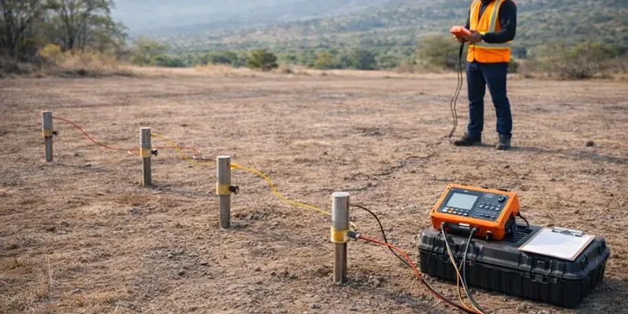
What is the difference between VES and 2D resistivity imaging?

VES gives you resistivity versus depth at one location. You get a layered model. 2D imaging uses a cable with 28 to 56 electrodes to build a continuous cross-section along a line. Imaging is better for finding lateral changes: a buried wall, a channel deposit, a contaminant boundary. We recommend VES when you need targeted depth information and imaging when the problem is horizontal variability.

Can resistivity testing find the water table?

Yes, usually. Water-saturated soil has much lower resistivity than dry soil. In Sault Ste Marie's clay-rich soils the contrast is strong. A saturated clay might read 15 ohm-m while the same clay above the water table reads 40 ohm-m. We still recommend installing a standpipe piezometer to confirm the interpreted depth, especially if groundwater elevation is critical to the design.

Do you need special access or permits for resistivity surveys?

No heavy equipment, no drilling, no excavation. We carry electrodes and cable by hand. For public right-of-way work we handle the street occupancy permit with the City of Sault Ste Marie engineering department. For private land we just need owner permission and a clear path to lay out the cable. Winter surveys are possible but frozen ground increases contact resistance; we use saltwater around the electrodes to get a good connection.

Location and service area

We serve projects in Sault Ste Marie and surrounding areas.

View larger map